Part 3: Thereness-ness
In “The Site of Memory,” Morrison describes her writing process as “a kind of literary archeology”: “On the basis of some information and a little bit of guesswork you journey to a site to see what remains were left behind and to reconstruct the world that these remains imply.” As part of reconstructing worlds in literature, worlds that had been overlooked or erased by dominant narratives and histories, Morrison developed her own system of mapping space and time. Beginning in the 1980s, she sketched blueprints, rendered diagrammatic timelines, and drafted hand-drawn maps of her novels’ key spaces, places, and character arcs. In the process, she quite literally reconstructed and constructed the worlds that her characters would inhabit.
“Thereness-ness,” a term that Morrison coined in her revision process, names the wide imagination she had for spaces, places, and how we move through them. “Thereness-ness” registers her careful and precise attention to geography and topography; it demands that we reconsider the centrality of place, mapping, and patterns of movement in her work and to her writing process. “Thereness-ness” also draws attention to the unique and graphically based systems of notation that she used to image narrative perspective and to imagine how characters would inhabit invented territories.
“They shoot the white girl first. With the rest they can take their time. No need to hurry out here. They are seventeen miles from a town which has ninety miles between it and any other. Hiding places will be plenty in the Convent, but there is time and the day has just begun.”

Geography underpins Morrison’s practice in quieter and less obvious ways. In a handwritten response to a query from a copy editor working on Beloved (1987), Morrison describes geography and distance as precise but also “rounded off.” Here, mileage is as much an exact figure as it is a feeling. A detailed map of Jazz’s (1992) Vesper County, Virginia accounts for the distance between neighborhoods and settings. Naming a place was as important as pinning it down on a map. An early draft of Beloved shows Morrison carefully crossing out the word “plantation” and replacing it with “farm” to describe Sweet Home, the work’s key site of enslavement. And hand-drawn graphics for the novels Paradise (1998) and Love (2003) evince her unique system of visually mapping narrative perspective.


House Sketch for Beloved
undated
Princeton University Library Special Collections
“Easily she stepped into the told story that lay before her eyes on the path she followed away from the window. There was only one door to the house and to get to it from the back you had to walk all the way around to the front of 124, past the storeroom, past the cold house, the privy, the shed, on around to the porch.”
Toni Morrison, Beloved
Outline of the Convent for Paradise
undated
Princeton University Library Special Collections
Paradise (1998) is set between Ruby, a fictional all-Black town in Oklahoma, and a former convent that is home to a group of women who become one another’s chosen family. This preliminary sketch shows Morrison beginning to imagine the shape of the convent, which is also the site of the novel’s opening murders.
Detailed Map of the Convent for Paradise
undated
Princeton University Library Special Collections
A detailed, hand-drawn line rendering of the convent. Here, Morrison fills in the initial outline with character’s sightlines and begins plotting where and how the novel’s opening moments and movements will take place.
Description of the Convent for Paradise
undated
Typed and handwritten
Princeton University Library Special Collections
Hand-written and typed descriptions of the convent’s rooms relating each space to significant moments in the lives and histories of Paradise’s characters.
Photographs of Oklahoma
1996
Frederick E. Cammersell, III
Princeton University Library Special Collections
Morrison wrote to her friend who was traveling through Oklahoma, asking him to take photographs of the landscape for her reference and affixed plot ideas and dialogue to specific images.

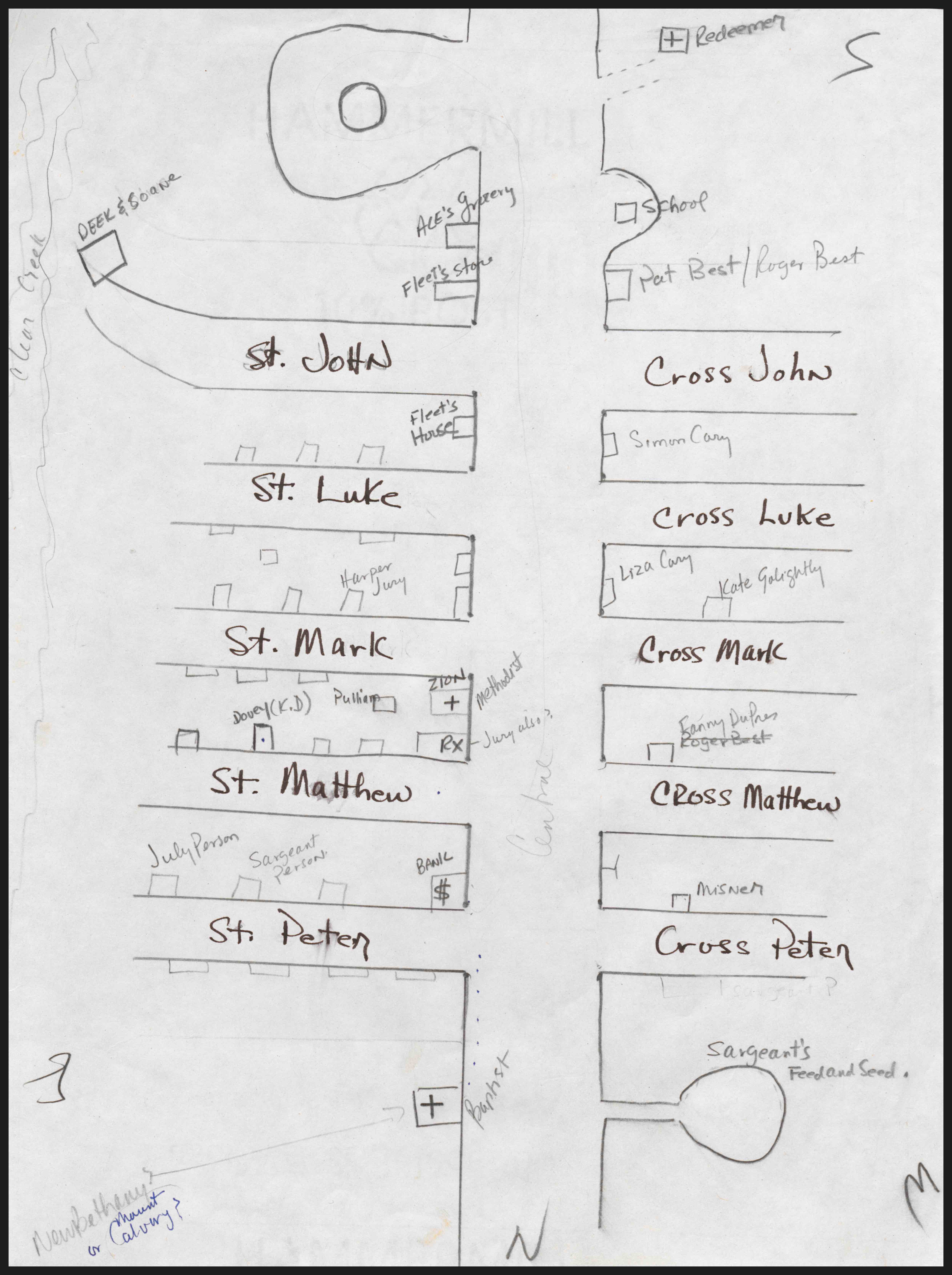
Map of Ruby #1 and #2
undated
Princeton University Library Special Collections
While drafting Paradise, Morrison created a series of maps and architectural renderings for the work’s key settings and locations. These two hand-drawn street maps detail the central district of Ruby, Oklahoma, the fictional Black town at the center of the novel.
Description of Ruby
undated
Princeton University Library Special Collections
A handwritten description of Ruby, its history, and how characters might move through its streets.
Description of Ruby’s Highway
undated
Princeton University Library Special Collections
Morrison was incredibly precise about geography in her novels. In this handwritten draft, she writes that the “road between Convent and Ruby is 15 miles of tarmac” and calculates how long it would take to walk it (“5 hours”). A small hand-drawn map of the tarmac in the lower corner underscores how critical mapping was to her creative process.
Editorial Correspondence on Beloved Page Proofs
April 27, 1999
Princeton University Library Special Collections
Map of Vesper County
undated
Princeton University Library Special Collections
Notes and Drafts, Beloved
undated
Princeton University Library Special Collections
Point of View Graphics, Paradise
undated
Princeton University Library Special Collections
Notes and Drafts, Love
undated
Princeton University Library Special Collections
